![]() Jamann
Jamann
| Home |
| The S/V Jamann |
| Past Adventures |
| VI General Info |
| Newsletter |
| Joy of Jamann Recipes |
| Contact Us |
|
We be Jamann!! |
|
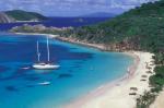
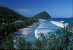
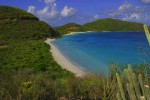
The Virgin Islands Location and Geography Known
as “the land that time forgot,” the British Virgin Islands remains an
undeveloped haven for natural treasures; what the destination lacks is
its greatest asset -- no high-rise hotels, no casinos and no crowds. Situated between the deep waters of the Atlantic and the glittering Caribbean Sea, just east of Puerto Rico. Other nearby neighbours include the United States Virgin Islands, located to the immediate south west of the BVI. Map of the British Virgin Islands Most islands lay in a distinct formation flanked around the Sir Frances Drake Channel -- including the main island of Tortola creating the backbone of the Channel, Virgin Gorda stretching to form the eastern border, Jost Van Dyke lingering in the west, Anegada dangling remotely north in the Atlantic and a series of smaller islands speckled in the south. Rising majestically out of the Caribbean Sea, the islands, nearly all mountainous with lush elevations, envelope visitors in the relaxing embrace of Caribbean lifestyle. Undisputed Sailing Capital of the World. Home to the Caribbean’s Best Wreck, the Wreck of the – Rhone. No building is taller than the highest palm tree. The US Virgin Islands may not be as large in number but are just as majestic in beauty. St. Thomas is the commercial center of the USVI and is quite easy to access from most major citiies in the US. St. John is two thirds national park. There are numerous bays and anchorages to be explored around both islands with beautiful sand beaches and great snorkeling and diving. There are also lots of things to do on the islands as well. Their little sister, St. Croix is located about 35 miles south of these two, just a beautiful day sail away. Although the three main islands are part of the US territory you'll still know that you are in islands with Caribbean cultural influences all around. The Spanish Virgin Islands of Culebra and Vieques are a part of Puerto Rico with Culebra only 25 miles and an easy day sail from St. Thomas. Known as Puerto Rico's best kept secret these islands are the up and coming destinations with lots of seculed locations to really enjoy nature at its finest. Map of the Spanish Virgin Islands Weather Perfect Atmosphere Year-round. Constant trade winds with average temperatures of 27-32°C (80-90°F). Lots of sunshine with occasional short rain showers. Documentation: Valid passport is the principal requirement for entry into the BVI and you are required to have a valid passport to enter the US. Your passport should be valid for at least 6 months beyond your return date. Current time for renewing passports is approximately 10-12 weeks (expedited service is available at additional costs). Since the USVI and Spanish VI are in the US no passport and no customs and immigrations hassles are needed for arriving US Citizens! Airport Security: For international flights it is recommended that you plan to arrive at the airport at least 2 hours prior to departure. Allow additional time for parking your car. See the TSA Security Guidelines for further details. General Information: Attire is casual. Shorts, t-shirts, short sleeved shirts, boat shoes, flip-flops and sandals. The evenings can sometimes get a little cool and/or breezy for which a light jacket or sweatshirt might come in handy. The VI are in the Atlantic time zone but do not observe daylight savings time. English is the official language througout the VI although Spanish is heavily used in the Spanish VI. And the US dollar is the official Currency - even in the British VI. Most major credit cards are accepted throughout the islands. Electricity is the 220 volt UK standard on shore in the BVI and 110 volt US standard on shore in the USVI and Spanish VI. Everything on the yacht is 12 volt running off the batteries. There are two 12 volt outlets which can be used with car lighter adapters to power/charge such things as iPods, MP3 players and small DVD players. The tap water is good but bottled water is readily available throughout the islands. There is a hospital on Tortola and St. Thomas with additional clinics in various locations. Remember to bring your prescription medications, cameras, sunscreen lotion, swimsuit, cover-up, comfortable walking shoes, and insect repellent. There isn’t any particular insect problem BUT mosquitoes and sand flys/fleas, also known as “no see-ums” can be found throughout the Caribbean. So be prepared. Insect repellents with deet work well as well as Avon’s Skin So Soft diluted 50%. For additional information:
|
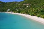
Anegada Loblolly Bay
The Baths on Virgin Gorda
Cane Garden Bay
Dead Man's Bay
Long Bay
Savannah Bay
Smuggler's Bay
White Bay, Jost Van Dyke |